
Sources Around Shoreline Neighbors
A block has several public layers, and each answers a different question. The county map shows how parcels fit together. The assessor supplies property-account facts. Recorded documents connect named parties to land events. Shoreline maps identify the city limit, neighborhoods, roads, parks, and civic facilities. The city's association inventory points toward public community contacts. No source is a complete list of Shoreline neighbors, and none proves that an owner, taxpayer, voter, or permit contact currently occupies a home.
| Source | What It Shows About a Block | Access |
|---|---|---|
| King County Parcel Viewer | Parcel shapes, nearby lots, selected sets, district links | Free online map |
| Assessor eReal Property | Taxpayer, legal description, land and building facts | Free property reports |
| Shoreline city and neighborhood maps | City limits, streets, parks, facilities, named civic areas | Dated PDF maps and GIS |
| Neighborhood association inventory | Public association contact and website information | City-maintained page |
| Historical directories and photos | Dated household, road, landmark, or building leads | Library, archives, and museum |
Use owner names only when the ownership fact is relevant. The situs address is the parcel's physical address, while a tax mailing address may point elsewhere. A recorded party may have sold or received an interest on one date. A permit contact can be an applicant or contractor. Treat each role as its label states. If the goal expands from the nearby lots to an entire road, the Shoreline street directory has the full address-keyed workflow.
Select Parcels Near Shoreline Neighbors
The King County Parcel Viewer accepts an address, parcel number, or condominium name. A user can click a map parcel, add parcels to a selection, select adjacent lots, create a buffer measured in feet, measure distance, change layers, and export a selected set. For roads that are easier to place by junction, use Find Intersection and its cross-street fields.
A buffer is a ring around a chosen map feature. It can show which parcels fall within a set distance, but it cannot identify a social relationship, household, or shared address. Parcel boundaries are approximate and are not a legal survey. Save the map date, selection method, and parcel identifiers so another person can reproduce the geographic result.
The official parcel map is captured below.
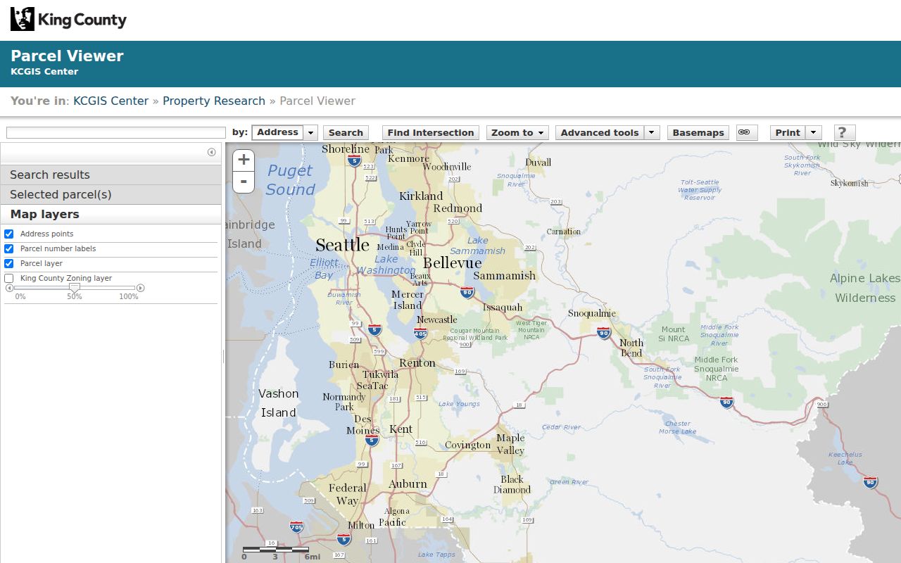
The map view supports a careful block study because the selected geometry remains separate from claims about people.
Map a Shoreline Block Carefully
Move from one known place outward in a fixed order. This keeps a neighbor lookup bounded to the block and prevents unrelated names from being mixed together. Use the map first, then open individual property reports only when a parcel fact is needed.
- Normalize the starting address through an official address or parcel search. Record the returned city and parcel number.
- Select the parcel, then use adjacent selection or a small buffer. Export only the parcels needed for the question.
- Open the county property report for relevant lots. Keep taxpayer, situs, mailing, and recorded-party fields separate.
- Check the dated Shoreline neighborhood map and district report for civic context, not personal identity.
- Verify any land event in the recorded instrument. Add the source and access date to the research note.
The county property report can lag a recent change, and a taxpayer is not necessarily an occupant. The Recorder's instrument is the source for the transfer itself. Even then, it proves a recorded land event rather than where every party lives.
Shoreline Neighbors Share Districts
Shoreline's official GIS and maps add non-sensitive context around a block. The city map updated February 13, 2026 marks city limits, parcels, roads, parks, schools, facilities, rail, and light-rail stations. The neighborhood map updated February 12, 2026 gives a separate civic geography. Parcel district reports can also identify Shoreline School District #412, fire, library, voting, legislative, congressional, and court districts.
Those boundaries do not all match. A postal city, municipal city, neighborhood, ZIP, school district, and fire district can overlap in different ways. Store the boundary type and map date with the result. This is especially important near Lake Forest Park, Seattle, Edmonds, and Woodway, and for places that existed before Shoreline incorporated in 1995.
Shoreline covers about 11.7 square miles, with about 191 miles of city streets and roughly 3.4 miles of Puget Sound shoreline in city quick facts. Those numbers describe the city as a whole, not any person. They explain why a short map radius can cross a park, rail corridor, commercial area, or another service boundary. A district result should therefore be read as a geographic label, never as a trait shared by all people within it.
Note: Civic districts explain shared services around Shoreline neighbors, but they reveal nothing about an individual household's private choices or relationships.
Contact Shoreline Neighborhood Groups
The city reports 14 neighborhood associations and maintains a contact and website inventory. The research could not verify a complete live transcription because the contact page returned an access error, so no guessed list of association names belongs here. Use the city association inventory for the current group, status, and public contact that matches the block.
Association Inventory
City of Shoreline neighborhood contacts and websites. Confirm the current association on the live city page.
Community Opportunities
Mallory Van Abbema
206-801-2253
mvanabbema@shorelinewa.gov
Shoreline Library
345 NE 175th St
206-362-7550
General local research and meeting resources
Active associations may use city facilities, liability coverage, supplies, service support, reimbursements, and mini-grants under current city rules. These are civic organizations, not comprehensive resident rosters. Public meeting notices and association websites can describe issues and projects without exposing a private membership list.
A useful request names the street or civic issue and asks for the public contact channel. It should not ask an association volunteer to disclose member names, phone numbers, email addresses, or private rosters. The city's Community Opportunities Coordinator is the better starting point when the association boundary or current status is unclear.
Historic Shoreline Blocks Changed
Shoreline blocks did not always use today's labels. Richmond Beach was platted in 1890. The Great Northern Railroad arrived in 1891, the Interurban trolley in 1906, and North Trunk Road brick work followed around 1912-1913. Aurora gained commercial development by the late 1930s, while many neighborhoods expanded after World War II. An older record may use a plat, rail stop, or road name instead of a modern address.
The Shoreline Historical Museum Photo Finder can be searched by road, school, neighborhood, landmark, or surname. As of May 18, 2024 it offered 2,071 photos, including dated views related to Echo Lake, Richmond Beach, the Interurban, and Playland. Captions supply leads, not proof about living residents. Tie a scene to a parcel, inventory, property card, or dated map before calling it the same site.
For a pre-1995 block, label the jurisdiction as unincorporated King County. County road, assessment, recording, and archival sources may hold the earlier file. City permits and local requests cover the post-incorporation period, with eTRAKiT beginning in 2001. That split is often more important than the neighborhood name when tracing how a block changed.
Official Shoreline Records Compare Better
Commercial neighbor tools often blend old addresses, phone data, and unnamed sources. Official records are narrower, but their custodian, date, field meaning, and correction route can be checked. That makes them more useful for a careful civic or property question.
| Route | Useful Strength | Main Limit |
|---|---|---|
| County and city records | Named custodian, defined fields, dated record | Each source covers only its legal purpose |
| Community association sources | Current public projects, meetings, and contacts | Not a complete household or member list |
| Commercial lookup category | May offer quick possible leads | Unclear dates, merging errors, stale or unsupported links |
When an official entry appears wrong, use that agency's correction process. Do not merge several weak matches into a claim about a person.
Capture only the details needed to answer the question. A parcel number, map date, district, and source link are often enough. Publishing a wider set of names adds risk without making the geographic finding more sound.
Protect Privacy Among Shoreline Neighbors
Public access does not erase privacy. The Washington Address Confidentiality Program can substitute an address in government records for eligible people facing serious safety threats. Actual street, mailing, city, county, precinct, and other identifying fields may be confidential. Court searches omit sealed or confidential matters, and public-record exemptions still apply. A missing person or substituted address is never proof that someone does not live in Shoreline.
Voter information has special limits. The county's My Voter Information tool is an identity-and-address check that requires any three of first name, last name, date of birth, and house number. It is not a downloadable directory of a block. Washington voter lists are subject to RCW 29A.08.720 and use restrictions. Keep a neighbor study focused on parcel geography, public civic contacts, and facts needed for a lawful purpose.
Lawful use. Research Shoreline neighbors for civic awareness, reconnecting, or personal safety. Never watch, follow, threaten, harass, or expose a protected person.